Gas station nearby Jurki
Slovakia
Gas station nearby Jurki
Jurki
16, Hraničná, 821 04, Bratislava II, Bratislavský kraj, SK Eslovaquia
contacts phone
:
+421 2/534 144 98
website:
www.jurki.sk
Latitude:
48.1467727
, Longitude:
17.1581544
larger map & directions
read more
nearest Gas station
423 m
Bennet Oil
Tučkova 1704/10, Bratislava
Gas station
read more
425 m
Čerpacia stanica - bez značky Bratislava
Prievozská 1325/32, Bratislava
Gas station
read more
1.007 km
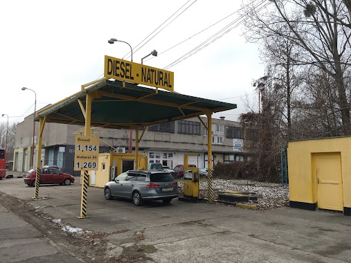
Jurki
Domkárska 4, Ružinov
Gas station
read more
1.124 km
Slovnaft
Bajkalská 23/A
Gas station
read more
1.128 km
Jurki Prístavná
Prístavná 12, Ružinov
Gas station
read more
1.154 km
Normbenz
Slovnaftská, Ružinov
Gas station
read more
1.193 km
Slovnaft
Herlianska 1, Bratislava
Gas station
read more
1.243 km
Shell
Bajkalská 7, Ružinov
Gas station
read more
1.264 km
Shell
Bajkalská ul. 7, Bratislava
Gas station
read more
1.548 km
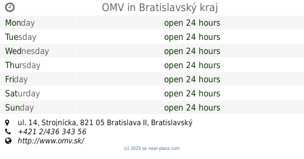
OMV Strojnícka
Strojnícka 14
Gas station
read more
1.594 km
OMV
Strojnícka ul. 14
Gas station
read more
1.644 km
Shell
Drieňová 5421, Bratislava
Gas station
read more
1.682 km
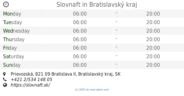
Slovnaft
Prievozská, Bratislava
Gas station
read more
1.693 km
Benzínová pumpa
Prievozská 15780/2, Bratislava
Gas station
read more
1.721 km
Jurki Cerpacia Stanica
Domové role, Ružinov
Gas station
read more
1.816 km
Bratislava - Prístavná
Prístavná
Gas station
read more
1.818 km
Slovnaft
Prístavná, Bratislava
Gas station
read more
2.016 km
Slovnaft
Tomášikova 36, Ružinov
Gas station
read more
2.16 km
Slovnaft
Vrakunská cesta 5391/22, Bratislava
Gas station
read more
2.228 km
OMV
Trnavská cesta 6, Bratislava
Gas station
read more
2.228 km
OMV Čerpacie stanice
Trnavská cesta 6, Bratislava
Gas station
read more
2.421 km
8205 Bratislava Roznavska
Rožňavská 731/6, Bratislava
Gas station
read more
2.537 km
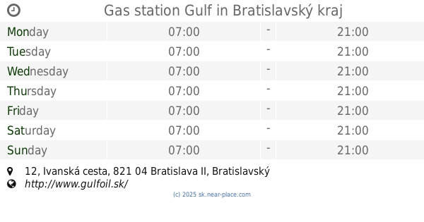
Gas station Gulf
Ivanská cesta 12, Ružinov
Gas station
read more
2.997 km
Ecotank stojan
12901,, Elektrárenská, Bratislava
Gas station
read more
3.211 km
Shell
Einsteinova 23, Bratislava
Gas station
read more
📑
all categories
Accounting
Administrative area level 1
Administrative area level 2
Airport
Amusement park
Aquarium
Art gallery
Atm
Bakery
Bank
Bar
Beauty salon
Bicycle store
Book store
Bowling alley
Bus station
Cafe
Campground
Car dealer
Car rental
Car repair
Car wash
Casino
Cemetery
Church
City hall
Clothing store
Convenience store
Courthouse
Dentist
Department store
Doctor
Electrician
Electronics store
Embassy
Establishment
Finance
Fire station
Florist
Food
Funeral home
Furniture store
Gas station
General contractor
Grocery or supermarket
Gym
Hair care
Hardware store
Health
Home goods store
Hospital
Insurance agency
Jewelry store
Laundry
Lawyer
Library
Light rail station
Liquor store
Local government office
Locality
Locksmith
Lodging
Meal delivery
Meal takeaway
Mosque
Movie rental
Movie theater
Moving company
Museum
Natural feature
Neighborhood
Night club
Painter
Park
Parking
Pet store
Pharmacy
Physiotherapist
Place of worship
Plumber
Point of interest
Police
Post office
Premise
Real estate agency
Restaurant
Roofing contractor
Route
Rv park, camping
School
Shoe store
Shopping mall
Spa
Stadium
Storage
Store
Subpremise
Supermarket
Synagogue
Taxi stand
Train station
Transit station
Travel agency
University
Veterinary care
Zoo
administrative area level 3
sublocality level 1
↑