Bar nearby Bar 29
Slovakia
Bar nearby Bar 29
Bar 29
444/10, Jurigovo nám, 841 04, Karlova Ves, Karlova Ves, SK Eslovaquia
contacts phone
:
+421
Latitude:
48.1516937
, Longitude:
17.0593067
larger map & directions
read more
nearest Bar
117 m
Karloveská Klubovňa
Jurigovo námestie, Bratislava
Bar
read more
294 m
Bar Fulda
Segnerova 2719, Karlova Ves
Bar
read more
495 m
Viecha U Kadnára
Líščie údolie 167/108, Karlova Ves
Bar
read more
740 m
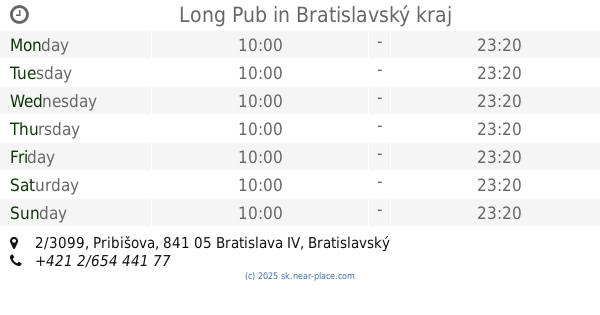
Long Pub
Pribišova 2/3099, Karlova Ves
Bar
read more
752 m
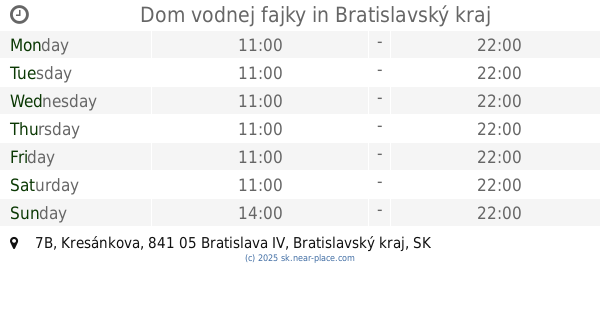
Dom vodnej fajky
Kresánkova 7B, Karlova Ves
Bar
read more
789 m
Kings Rock Pub
Botanická 6197/35, Karlova Ves
Bar
read more
796 m
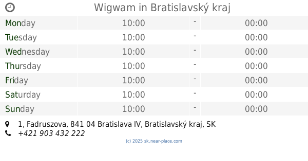
Wigwam
Fadruszova 726/1, Karlova Ves
Bar
read more
801 m
University Club Elam
Staré Grunty 5913/53, Karlova Ves
Bar
read more
947 m
rePUBlike
Nám. sv. Františka 16 3406 3406, Karlova Ves
Bar
read more
961 m
mojevino.sk
Jamnického 3022/12, Karlova Ves
Bar
read more
971 m
Buddha Cafe
Karlova Ves
Bar
read more
1.015 km
Estévéčka
Staré Grunty 23, Karlova Ves
Bar
read more
1.029 km
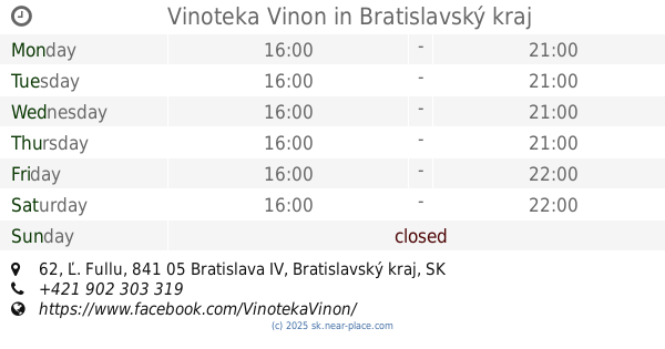
Vinoteka Vinon
Ľ. Fullu 62, Karlova Ves
Bar
read more
1.397 km
Abyss Netcafe & Lounge
Zohorská 1, Karlova Ves
Bar
read more
1.495 km
Lišiak Výčap
Púpavová 681, Karlova Ves
Bar
read more
2.239 km
Patrónsky Pivovar
Brnianska 3732/57, Bratislava
Bar
read more
2.239 km
Patrónsky Pivovar
Brnianska 3732/57, Staré Mesto
Bar
read more
2.261 km
Bufet Bodega
Dúbravská cesta 3397, Karlova Ves
Bar
read more
2.307 km
Krčma na Patrónke
Old Town
Bar
read more
2.904 km
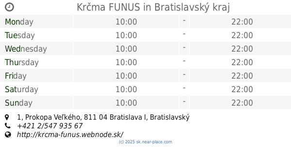
Krčma FUNUS
Prokopa Veľkého 1, Staré Mesto
Bar
read more
3.032 km
MINI PUB
Palisády, Staré Mesto
Bar
read more
3.16 km
Blind Pig
Žižkova 4449/1, Bratislava
Bar
read more
3.345 km
Piváreň u Jozefa
Stará Klenová 1689/9, Nové Mesto
Bar
read more
3.538 km
Mr.Boogie
Pečnianska 3430/6, Petržalka
Bar
read more
3.802 km
Mini Bar 158
Nobelovo námestie 5, Petržalka
Bar
read more
📑
all categories
Accounting
Administrative area level 1
Administrative area level 2
Airport
Amusement park
Aquarium
Art gallery
Atm
Bakery
Bank
Bar
Beauty salon
Bicycle store
Book store
Bowling alley
Bus station
Cafe
Campground
Car dealer
Car rental
Car repair
Car wash
Casino
Cemetery
Church
City hall
Clothing store
Convenience store
Courthouse
Dentist
Department store
Doctor
Electrician
Electronics store
Embassy
Establishment
Finance
Fire station
Florist
Food
Funeral home
Furniture store
Gas station
General contractor
Grocery or supermarket
Gym
Hair care
Hardware store
Health
Home goods store
Hospital
Insurance agency
Jewelry store
Laundry
Lawyer
Library
Light rail station
Liquor store
Local government office
Locality
Locksmith
Lodging
Meal delivery
Meal takeaway
Mosque
Movie rental
Movie theater
Moving company
Museum
Natural feature
Neighborhood
Night club
Painter
Park
Parking
Pet store
Pharmacy
Physiotherapist
Place of worship
Plumber
Point of interest
Police
Post office
Premise
Real estate agency
Restaurant
Roofing contractor
Route
Rv park, camping
School
Shoe store
Shopping mall
Spa
Stadium
Storage
Store
Subpremise
Supermarket
Synagogue
Taxi stand
Train station
Transit station
Travel agency
University
Veterinary care
Zoo
administrative area level 3
sublocality level 1
↑