Bar nearby Herňa Maxim
Slovakia
Bar nearby Herňa Maxim
Herňa Maxim
20, Trhová, 841 01, Bratislava IV, Bratislavský kraj, SK Slovakia
contacts phone
:
+421
Latitude:
48.1875143
, Longitude:
17.0388481
larger map & directions
read more
nearest Bar
858 m
Bufet Kotrmelec
Lamačská cesta 6666, Lamač
Bar
read more
942 m
Herňa excelclub
M. Schneidera-Trnavského 4, Dúbravka
Bar
read more
946 m
Herňa excel club
M. Schneidera-Trnavského 4, Dúbravka
Bar
read more
1.013 km
Luvra 69
M. Schneidera-Trnavského 4, Dúbravka
Bar
read more
1.11 km
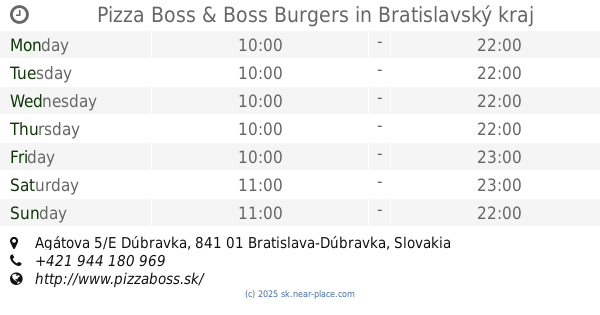
Pizza Boss & Boss Burgers
Agátova 5/E Dúbravka, Dúbravka
Bar
read more
1.473 km
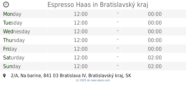
Espresso Haas
Na barine 2/A, Lamač
Bar
read more
2.777 km
Lišiak Výčap
Púpavová 681, Karlova Ves
Bar
read more
2.904 km
Abyss Netcafe & Lounge
Zohorská 1, Karlova Ves
Bar
read more
3.112 km
U Billa
Cesta na, Cesta na Červený most 4227/8, Bratislava
Bar
read more
3.45 km
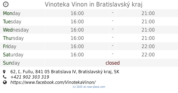
Vinoteka Vinon
Ľ. Fullu 62, Karlova Ves
Bar
read more
3.462 km
Krčma na Patrónke
Old Town
Bar
read more
3.497 km
Bufet Bodega
Dúbravská cesta 3397, Karlova Ves
Bar
read more
3.894 km
Patrónsky Pivovar
Brnianska 3732/57, Bratislava
Bar
read more
3.894 km
Patrónsky Pivovar
Brnianska 3732/57, Staré Mesto
Bar
read more
4.268 km
Karloveská Klubovňa
Jurigovo námestie, Bratislava
Bar
read more
4.366 km
Piváreň u Jozefa
Stará Klenová 1689/9, Nové Mesto
Bar
read more
4.915 km
Sport Pub Esso
Pavla Horova 6146/12, Devínska Nová Ves
Bar
read more
5.445 km
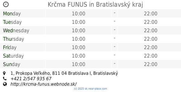
Krčma FUNUS
Prokopa Veľkého 1, Staré Mesto
Bar
read more
6.179 km
FLAME Music Bar
Štefánikova 897/47, Bratislava
Bar
read more
6.526 km
MINI PUB
Palisády, Staré Mesto
Bar
read more
6.527 km
Kaviareň Destiny
Panenská 664/16, Bratislava
Bar
read more
6.849 km
Schwarzer Hund
Na vŕšku 338/2
Bar
read more
6.876 km
ŽIVÉ VÍNA, vínny bar
Baštová 347/4, Bratislava
Bar
read more
6.892 km
Funki Punki pancakes
Klariská 327/12, Bratislava
Bar
read more
6.941 km
Teabar on the walls
Úzka 6639/11, Bratislava
Bar
read more
📑
all categories
Accounting
Administrative area level 1
Administrative area level 2
Airport
Amusement park
Aquarium
Art gallery
Atm
Bakery
Bank
Bar
Beauty salon
Bicycle store
Book store
Bowling alley
Bus station
Cafe
Campground
Car dealer
Car rental
Car repair
Car wash
Casino
Cemetery
Church
City hall
Clothing store
Convenience store
Courthouse
Dentist
Department store
Doctor
Electrician
Electronics store
Embassy
Establishment
Finance
Fire station
Florist
Food
Funeral home
Furniture store
Gas station
General contractor
Grocery or supermarket
Gym
Hair care
Hardware store
Health
Home goods store
Hospital
Insurance agency
Jewelry store
Laundry
Lawyer
Library
Light rail station
Liquor store
Local government office
Locality
Locksmith
Lodging
Meal delivery
Meal takeaway
Mosque
Movie rental
Movie theater
Moving company
Museum
Natural feature
Neighborhood
Night club
Painter
Park
Parking
Pet store
Pharmacy
Physiotherapist
Place of worship
Plumber
Point of interest
Police
Post office
Premise
Real estate agency
Restaurant
Roofing contractor
Route
Rv park, camping
School
Shoe store
Shopping mall
Spa
Stadium
Storage
Store
Subpremise
Supermarket
Synagogue
Taxi stand
Train station
Transit station
Travel agency
University
Veterinary care
Zoo
administrative area level 3
sublocality level 1
↑