Bar nearby Pod Višňou
Slovakia
Bar nearby Pod Višňou
Pod Višňou
2, Majerská, 821 07, Bratislava II, Bratislavský kraj, SK Slovakia
contacts phone
:
+421
Latitude:
48.1520361
, Longitude:
17.2017928
larger map & directions
read more
nearest Bar
993 m
Kaviareň - Cukráreň Lemon
Hradská 8518/124, Vrakuňa
Bar
read more
993 m
Craft Beer Pub Lemon
Hradská 8518/124, Bratislava
Bar
read more
1.034 km
Gremlin's
Rajecká 8692/9, Bratislava
Bar
read more
1.382 km
Dobrá Krčma
Žitavská 5045/5, Bratislava
Bar
read more
1.39 km
Hostinec U Paroháčov
Vŕbová 8801/14, Bratislava
Bar
read more
1.52 km
Pizza Colosseum
Železničná 13137/100, Bratislava
Bar
read more
1.662 km
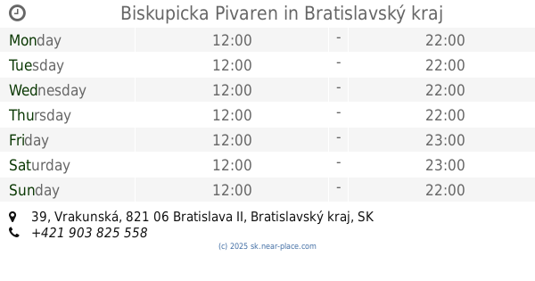
Biskupicka Pivaren
Vrakunská 39, Podunajské Biskupice
Bar
read more
1.665 km
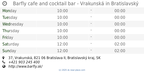
Barfly cafe and cocktail bar - Vrakunská
Vrakunská 12521/37, Bratislava
Bar
read more
1.691 km
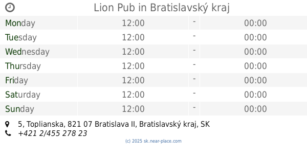
Lion Pub
Toplianska 5077/5, Vrakuňa
Bar
read more
1.76 km
Levicka Viecha
Závodná 10146/32, Bratislava
Bar
read more
1.867 km
Pub Hron
Dudvážska 5, Podunajské Biskupice
Bar
read more
1.939 km
Herňa Merlin
Ipeľská, Bratislava
Bar
read more
1.96 km
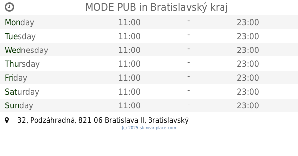
MODE PUB
Podzáhradná 10085/32, Bratislava
Bar
read more
1.971 km
La Putika 6
Ružinovská 44, Ružinov
Bar
read more
1.992 km
Pizzeria Fantozzi
Slovakia
Bar
read more
1.994 km
Hostinec na rohu
Mierová 2107/160, Bratislava
Bar
read more
1.994 km
Buffalo Pub
Ipeľská 5136/4, Podunajské Biskupice
Bar
read more
2.162 km
Mustang Bar
Ivanská cesta 5740/16, Bratislava
Bar
read more
2.298 km
Staropramen
Ivanská cesta 16
Bar
read more
2.31 km
pub Porter
Seberíniho 14, Ružinov
Bar
read more
2.467 km
Barfly cafe&cocktail bar - Mierová
Mierová 27, Bratislava
Bar
read more
2.644 km
Don Papa Bar
Seberíniho 5705/2A, Ružinov
Bar
read more
2.795 km
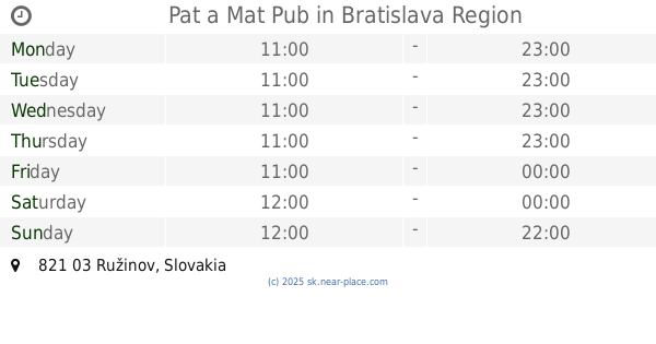
Pat a Mat Pub
Ružinov
Bar
read more
3.042 km
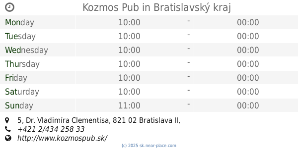
Kozmos Pub
Dr. Vladimíra Clementisa 5, Ružinov
Bar
read more
3.146 km
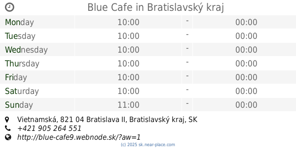
Blue Cafe
Vietnamská, Ružinov
Bar
read more
📑
all categories
Accounting
Administrative area level 1
Administrative area level 2
Airport
Amusement park
Aquarium
Art gallery
Atm
Bakery
Bank
Bar
Beauty salon
Bicycle store
Book store
Bowling alley
Bus station
Cafe
Campground
Car dealer
Car rental
Car repair
Car wash
Casino
Cemetery
Church
City hall
Clothing store
Convenience store
Courthouse
Dentist
Department store
Doctor
Electrician
Electronics store
Embassy
Establishment
Finance
Fire station
Florist
Food
Funeral home
Furniture store
Gas station
General contractor
Grocery or supermarket
Gym
Hair care
Hardware store
Health
Home goods store
Hospital
Insurance agency
Jewelry store
Laundry
Lawyer
Library
Light rail station
Liquor store
Local government office
Locality
Locksmith
Lodging
Meal delivery
Meal takeaway
Mosque
Movie rental
Movie theater
Moving company
Museum
Natural feature
Neighborhood
Night club
Painter
Park
Parking
Pet store
Pharmacy
Physiotherapist
Place of worship
Plumber
Point of interest
Police
Post office
Premise
Real estate agency
Restaurant
Roofing contractor
Route
Rv park, camping
School
Shoe store
Shopping mall
Spa
Stadium
Storage
Store
Subpremise
Supermarket
Synagogue
Taxi stand
Train station
Transit station
Travel agency
University
Veterinary care
Zoo
administrative area level 3
sublocality level 1
↑