Cemetery nearby Cintorín
Slovakia
Cemetery nearby Cintorín
Cintorín
919 01 Dlhá, Słowacja
contacts phone
:
+421
Latitude:
48.4095944
, Longitude:
17.4295621
larger map & directions
read more
nearest Cemetery
2.474 km
Cintorín
Borová 54
Cemetery
read more
3.791 km
Cintorín Štefanová
Štefanová
Cemetery
read more
5.413 km
Cintorín Zvončín
Suchovská
Cemetery
read more
6.63 km
Cintorín
Ružindol 210
Cemetery
read more
8.784 km
Cintorín
Biely Kostol
Cemetery
read more
8.796 km
Cintorín
Jablonec
Cemetery
read more
10.726 km
Správa cintorínov
Trnava
Cemetery
read more
11.176 km
Nový cintorín
Štefana Moyzesa 853/14, Cífer
Cemetery
read more
23.324 km
Cintorín Svätý Jur I.
Svätý Jur
Cemetery
read more
29.444 km
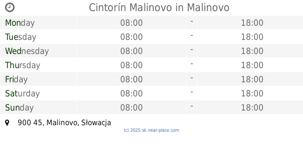
Cintorín Malinovo
900 45
Cemetery
read more
32.595 km
Židovský cintorín
Stupava
Cemetery
read more
34.254 km
Cintorín
Kaméliová 8562/2, Bratislava
Cemetery
read more
34.289 km
Cintorín Vrakuňa
Vrakuňa
Cemetery
read more
35.047 km
Cintorín
Stachanovská 2175/59, Bratislava
Cemetery
read more
35.077 km
Cintorín Prievoz
Ružinov
Cemetery
read more
35.185 km
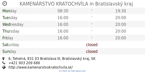
KAMENÁRSTVO KRATOCHVÍLA
Tehelná 226/6, Bratislava
Cemetery
read more
36.838 km
Hrob herca Juliusa Satinského
Poľná 2608/9, Bratislava
Cemetery
read more
37.175 km
lower cemetery
Športová 510
Cemetery
read more
38.943 km
New Jewish Cemetery
Žižkova 36, Staré Mesto
Cemetery
read more
39.771 km
Cintorín Karlova Ves
Adámiho 6152, Karlova Ves
Cemetery
read more
41.188 km
Cintorín Petržalka
Petržalka
Cemetery
read more
42.332 km
Vojenský cintorín z 1. sv. vojny
Bratislava
Cemetery
read more
48.632 km
Jewish Cemetary
Pražská 698, Nitra
Cemetery
read more
49.451 km
Cintorín
Nitra
Cemetery
read more
49.513 km
Námestie Kráľovnej pokoja
16,, Cintorínska 2729/14, Nitra
Cemetery
read more
📑
all categories
Accounting
Administrative area level 1
Administrative area level 2
Airport
Amusement park
Aquarium
Art gallery
Atm
Bakery
Bank
Bar
Beauty salon
Bicycle store
Book store
Bowling alley
Bus station
Cafe
Campground
Car dealer
Car rental
Car repair
Car wash
Casino
Cemetery
Church
City hall
Clothing store
Convenience store
Courthouse
Dentist
Department store
Doctor
Electrician
Electronics store
Embassy
Establishment
Finance
Fire station
Florist
Food
Funeral home
Furniture store
Gas station
General contractor
Grocery or supermarket
Gym
Hair care
Hardware store
Health
Home goods store
Hospital
Insurance agency
Jewelry store
Laundry
Lawyer
Library
Light rail station
Liquor store
Local government office
Locality
Locksmith
Lodging
Meal delivery
Meal takeaway
Mosque
Movie rental
Movie theater
Moving company
Museum
Natural feature
Neighborhood
Night club
Painter
Park
Parking
Pet store
Pharmacy
Physiotherapist
Place of worship
Plumber
Point of interest
Police
Post office
Premise
Real estate agency
Restaurant
Roofing contractor
Route
Rv park, camping
School
Shoe store
Shopping mall
Spa
Stadium
Storage
Store
Subpremise
Supermarket
Synagogue
Taxi stand
Train station
Transit station
Travel agency
University
Veterinary care
Zoo
administrative area level 3
sublocality level 1
↑