Gas station nearby ČS Slovnaft
Slovakia
Gas station nearby ČS Slovnaft
ČS Slovnaft
49, Botanická, 841 04, Bratislava IV, Bratislavský kraj, SK Slowakei
contacts phone
:
+421
website:
slovnaft.sk
Latitude:
48.1480212
, Longitude:
17.0659182
larger map & directions
read more
nearest Gas station
2 m
Slovnaft
Botanická 1, Karlova Ves
Gas station
read more
329 m
Shell
Karloveská 4
Gas station
read more
332 m
Shell
Karloveská 5366/4, Bratislava
Gas station
read more
338 m
Shell
Karloveská 34, Karlova Ves
Gas station
read more
417 m
OMV Čerpacie stanice
Botanická ul. 25 BRATISLAVA
Gas station
read more
1.669 km
OMV
Ml. dolina - Machnáč 23, Bratislava
Gas station
read more
2.328 km
OMV
Brnianska 38, Staré Mesto
Gas station
read more
2.88 km
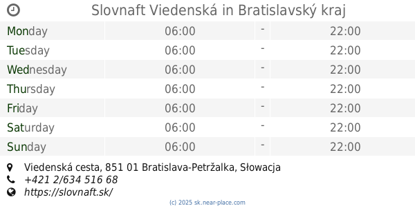
Slovnaft Viedenská
Viedenská cesta
Gas station
read more
3.122 km
OMV
Lamačská cesta 1B, Lamač
Gas station
read more
3.679 km
OMV Čerpacie stanice
Einsteinova 19, Bratislava
Gas station
read more
3.713 km
OMV
Einsteinova 17, Bratislava
Gas station
read more
3.713 km
OMV
Einsteinova 17
Gas station
read more
3.744 km
Slovnaft
ul, M. Schneidera-Trnavského, Bratislava
Gas station
read more
3.775 km
Slovnaft
Lamačská cesta
Gas station
read more
3.825 km
Železničná stanica Petržalka
Panónska cesta 34, Petržalka
Gas station
read more
3.849 km
Avanti Tankstelle
Hauptstraße 63, Wolfsthal
Gas station
read more
3.873 km
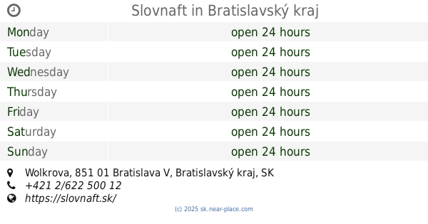
Slovnaft
Wolkrova, Bratislava
Gas station
read more
4.372 km
1.SPS
Na vrátkach, Dúbravka
Gas station
read more
4.605 km
Shell
Einsteinova 23, Bratislava
Gas station
read more
4.708 km
Jurki
Kopčianska 65, Petržalka
Gas station
read more
4.878 km
Gas station Oliva
Panónska cesta, Petržalka
Gas station
read more
5.131 km
OMV Čerpacie stanice
Panónska cesta 8, Bratislava
Gas station
read more
5.641 km
OMV Čerpacie stanice
Račianska ul 66 Bratislava
Gas station
read more
5.641 km
OMV
Račianska ul 66 Bratislava
Gas station
read more
6.079 km
Slovnaft
Dolnozemská 6, Bratislava Bratislava Bratislava
Gas station
read more
📑
all categories
Accounting
Administrative area level 1
Administrative area level 2
Airport
Amusement park
Aquarium
Art gallery
Atm
Bakery
Bank
Bar
Beauty salon
Bicycle store
Book store
Bowling alley
Bus station
Cafe
Campground
Car dealer
Car rental
Car repair
Car wash
Casino
Cemetery
Church
City hall
Clothing store
Convenience store
Courthouse
Dentist
Department store
Doctor
Electrician
Electronics store
Embassy
Establishment
Finance
Fire station
Florist
Food
Funeral home
Furniture store
Gas station
General contractor
Grocery or supermarket
Gym
Hair care
Hardware store
Health
Home goods store
Hospital
Insurance agency
Jewelry store
Laundry
Lawyer
Library
Light rail station
Liquor store
Local government office
Locality
Locksmith
Lodging
Meal delivery
Meal takeaway
Mosque
Movie rental
Movie theater
Moving company
Museum
Natural feature
Neighborhood
Night club
Painter
Park
Parking
Pet store
Pharmacy
Physiotherapist
Place of worship
Plumber
Point of interest
Police
Post office
Premise
Real estate agency
Restaurant
Roofing contractor
Route
Rv park, camping
School
Shoe store
Shopping mall
Spa
Stadium
Storage
Store
Subpremise
Supermarket
Synagogue
Taxi stand
Train station
Transit station
Travel agency
University
Veterinary care
Zoo
administrative area level 3
sublocality level 1
↑