Park nearby Medical garden
Slovakia
Park nearby Medical garden
Medical garden
57, Špitálska, 811 08, Bratislava I, Bratislavský kraj, SK Słowacja
contacts phone
:
+421 2/592 461 11
website:
www.bratislava.sk
Latitude:
48.1496658
, Longitude:
17.1196973
larger map & directions
read more
nearest Park
197 m
Fontána pred Avionom
Americké námestie, Staré Mesto
Park
read more
355 m
Fontána Nataša
Záhradnícka, Staré Mesto
Park
read more
376 m
Psí park Poľná
Poľná, Bratislava
Park
read more
522 m
Tatra Sports
Kollárovo nám. 2935/16
Park
read more
590 m
Act of a Woman (Susan)
Karadžičova, Staré Mesto
Park
read more
599 m
Kmeťovo námestie
Staré Mesto
Park
read more
617 m
Park Kmeťové námestie
Kmeťovo námestie 4-5, Bratislava
Park
read more
651 m
Fountain of Union
Námestie slobody, Staré Mesto
Park
read more
657 m
Freedom Square
Námestie slobody 2902/6, Bratislava
Park
read more
802 m
Lev s erbom
Námestie SNP, Staré Mesto
Park
read more
847 m
Poézia (Marína)
Šafárikovo námestie, Staré Mesto
Park
read more
861 m
Presidential Garden
Banskobystrická 3027/8, Bratislava
Park
read more
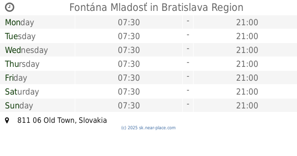
880 m
Fontána Mladosť
Old Town
Park
read more
892 m
Park Zahradnicka
Záhradnícka 4879/40, Bratislava
Park
read more
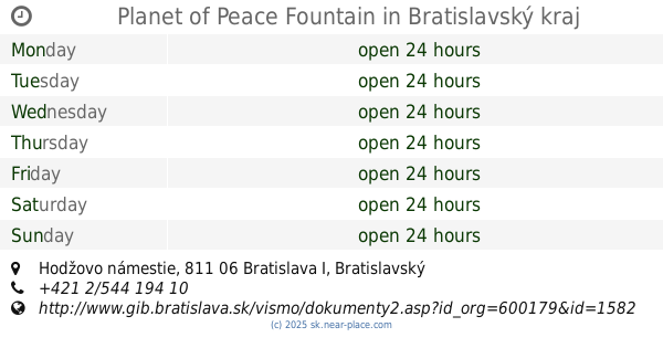
899 m
Planet of Peace Fountain
Hodžovo námestie, Staré Mesto
Park
read more
943 m
Nábytok Wood Design Bratislava
Páričkova 1127/14, Bratislava
Park
read more
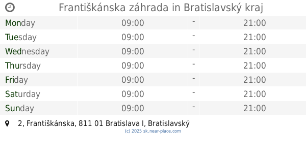
956 m
Františkánska záhrada
Františkánska 2, Bratislava
Park
read more
986 m
Fontána sv. Juraja
Primaciálne námestie, Staré Mesto
Park
read more
995 m
Fontána Račianske mýto
Račianske mýto, Nové Mesto
Park
read more
1.027 km
Panorama Park
Staré Mesto
Park
read more
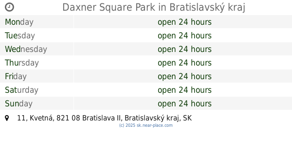
1.061 km
Daxner Square Park
Kvetná 1024/11, Bratislava
Park
read more
1.11 km
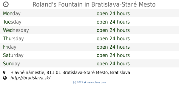
Roland's Fountain
Hlavné námestie
Park
read more
1.445 km
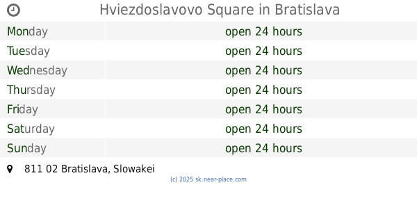
Hviezdoslavovo Square
Bratislava
Park
read more
1.772 km
Park Jama
Kalinčiakova 7268/27A, Bratislava
Park
read more
1.953 km
Vinica a mobilná záhrada
Pionierska, Nové Mesto
Park
read more
📑
all categories
Accounting
Administrative area level 1
Administrative area level 2
Airport
Amusement park
Aquarium
Art gallery
Atm
Bakery
Bank
Bar
Beauty salon
Bicycle store
Book store
Bowling alley
Bus station
Cafe
Campground
Car dealer
Car rental
Car repair
Car wash
Casino
Cemetery
Church
City hall
Clothing store
Convenience store
Courthouse
Dentist
Department store
Doctor
Electrician
Electronics store
Embassy
Establishment
Finance
Fire station
Florist
Food
Funeral home
Furniture store
Gas station
General contractor
Grocery or supermarket
Gym
Hair care
Hardware store
Health
Home goods store
Hospital
Insurance agency
Jewelry store
Laundry
Lawyer
Library
Light rail station
Liquor store
Local government office
Locality
Locksmith
Lodging
Meal delivery
Meal takeaway
Mosque
Movie rental
Movie theater
Moving company
Museum
Natural feature
Neighborhood
Night club
Painter
Park
Parking
Pet store
Pharmacy
Physiotherapist
Place of worship
Plumber
Point of interest
Police
Post office
Premise
Real estate agency
Restaurant
Roofing contractor
Route
Rv park, camping
School
Shoe store
Shopping mall
Spa
Stadium
Storage
Store
Subpremise
Supermarket
Synagogue
Taxi stand
Train station
Transit station
Travel agency
University
Veterinary care
Zoo
administrative area level 3
sublocality level 1
↑