Gas station nearby OMV
Slovakia
Gas station nearby OMV
OMV
D2, 851 10, Bratislava V, Bratislavský kraj, SK Slovakia
contacts phone
:
+421 2/625 284 75
website:
www.omv.sk
Latitude:
48.086095
, Longitude:
17.100082
larger map & directions
read more
nearest Gas station
OMV Čerpacie stanice
D2, Jarovce
Gas station
read more
222 m
OMV
Jarovce, D2, Jarovce
Gas station
read more
2.289 km
OMV
Panónska cesta 8, Bratislava
Gas station
read more
2.289 km
OMV Čerpacie stanice
Panónska cesta 8, Bratislava
Gas station
read more
2.505 km
Gas station Oliva
Panónska cesta, Petržalka
Gas station
read more
2.682 km
Jurki
Kopčianska 65, Petržalka
Gas station
read more
2.718 km
Lagerhaus Genol Tankstelle
Betriebsstraße 6, Kittsee
Gas station
read more
2.761 km
Slovnaft
Bratská 1, Petržalka
Gas station
read more
2.87 km
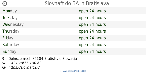
Slovnaft do BA
Dolnozemská
Gas station
read more
3.132 km
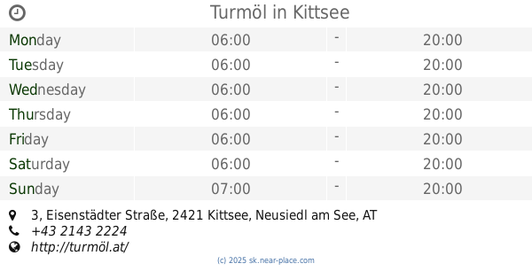
Turmöl
Eisenstädter Straße 3, Kittsee
Gas station
read more
3.539 km
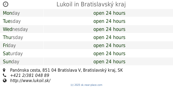
Lukoil
Panónska cesta, Petržalka
Gas station
read more
3.68 km
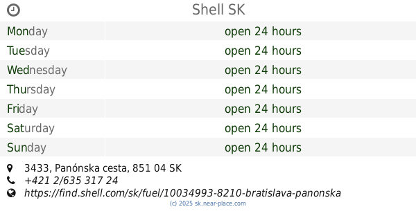
Shell
Panónska cesta 3433, Bratislava
Gas station
read more
3.89 km
Slovnaft
Dolnozemská 6, Bratislava Bratislava Bratislava
Gas station
read more
3.925 km
Železničná stanica Petržalka
Panónska cesta 34, Petržalka
Gas station
read more
4.375 km
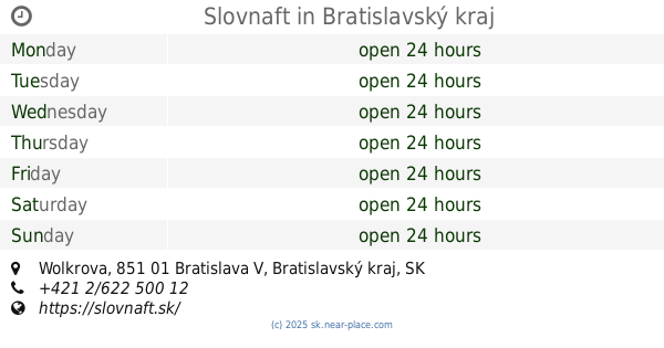
Slovnaft
Wolkrova, Bratislava
Gas station
read more
5.028 km
OMV Čerpacie stanice
Einsteinova 19, Bratislava
Gas station
read more
5.028 km
OMV
Einsteinova 19, Bratislava
Gas station
read more
5.049 km
OMV
Einsteinova 17
Gas station
read more
5.219 km
Shell
Einsteinova 23, Bratislava
Gas station
read more
6.963 km
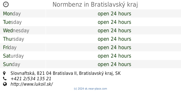
Normbenz
Slovnaftská, Ružinov
Gas station
read more
8.006 km
Jurki
Hraničná 16, Ružinov
Gas station
read more
9.216 km
OMV Strojnícka
Strojnícka 14
Gas station
read more
9.537 km
Slovnaft
Tomášikova 36, Ružinov
Gas station
read more
10.351 km
Ecotank stojan
12901,, Elektrárenská, Bratislava
Gas station
read more
11.525 km
OMV
Vajnorská 167, Bratislava
Gas station
read more
📑
all categories
Accounting
Administrative area level 1
Administrative area level 2
Airport
Amusement park
Aquarium
Art gallery
Atm
Bakery
Bank
Bar
Beauty salon
Bicycle store
Book store
Bowling alley
Bus station
Cafe
Campground
Car dealer
Car rental
Car repair
Car wash
Casino
Cemetery
Church
City hall
Clothing store
Convenience store
Courthouse
Dentist
Department store
Doctor
Electrician
Electronics store
Embassy
Establishment
Finance
Fire station
Florist
Food
Funeral home
Furniture store
Gas station
General contractor
Grocery or supermarket
Gym
Hair care
Hardware store
Health
Home goods store
Hospital
Insurance agency
Jewelry store
Laundry
Lawyer
Library
Light rail station
Liquor store
Local government office
Locality
Locksmith
Lodging
Meal delivery
Meal takeaway
Mosque
Movie rental
Movie theater
Moving company
Museum
Natural feature
Neighborhood
Night club
Painter
Park
Parking
Pet store
Pharmacy
Physiotherapist
Place of worship
Plumber
Point of interest
Police
Post office
Premise
Real estate agency
Restaurant
Roofing contractor
Route
Rv park, camping
School
Shoe store
Shopping mall
Spa
Stadium
Storage
Store
Subpremise
Supermarket
Synagogue
Taxi stand
Train station
Transit station
Travel agency
University
Veterinary care
Zoo
administrative area level 3
sublocality level 1
↑